

Chilkoot Trail Hiking Guide for 2023
JUMP TO: PROS & CONS | ITINERARIES | TRAIL DESCRIPTION | WHEN TO GO | CAMPSITES | NAVIGATION | WATER | WILDLIFE | TRAILHEAD SERVICES | WHAT TO PACK
Author: Steve Edgerton | Updated: Feb 15, 2023
We may earn a commission when you buy through our links. Learn more.
The Chilkoot Trail is a 3-5 day backcountry hike crossing the border between southeast Alaska and northwest British Columbia.
The Chilkoot Trail in its modern form takes hikers through temperate rainforest, glowing alpine tundra, and along pristine subarctic lakes. As an introduction to the Alaskan and northern Canadian backcountry, it doesn’t disappoint.
Decades before the Chilkoot Trail became a world-class backpacking destination, it was trod by gold miners on their way hundreds of miles further inland to the Klondike goldfields. For centuries before that, it was a key route for the Tlingit peoples traveling between the coast and inland Alaska and Canada’s Yukon Territory.
The Pass was the path of least resistance over the mountains. It also happens to be stunningly gorgeous.

The surreal scenery amidst the Chilkoot Pass
PROS
Coastal rainforest that transitions into surreal alpine landscapes
Well-maintained trails and campgrounds
Finish with a memorable train ride ride back to your car
CONS
Wildlife: you’re more likely to see bear than not
Often wet and rainy in the rainforest
It’s a busy trail — 50 backpacking trail permits are issued daily
ITINERARIES
The Chilkoot Trail is a point-to-point hike. You can go in either direction, but it is almost universally completed south to north, beginning outside the town of Skagway and ending at Bennett Lake.
Unfortunately, the pandemic has made completing the entire Chilkoot Trail impossible since 2020. Although it is expected that access to the full trail will resume in 2023, hikers are still restricted to either the American or Canadian side in 2022. You can do an out-and-back from the Dyea trailhead to Chilkoot Pass, or an out-and-back from Bennett Lake to Chilkoot Pass.
Spending four nights and five days on the Chilkoot Trail is the most common itinerary and though it cannot be completed in 2022, it is the one we detail here to help you prepare for its likely return in 2023.
In the alpine along the Chilkoot Trail
The best—and most popular—campgrounds for the four-night itinerary are Canyon City, Sheep Camp, Happy Camp, and Bare Loon Lake. Following this itinerary, you will find yourself staying with the same group of hikers night after night. The camaraderie and connections built over the hike because of this can be one of the highlights of the trip.
However, experienced hikers may find this pace a little too relaxing, spending more of the day at camp than on the trail. A good three-night trip could include stays at Sheep Camp, Happy Camp, and Bare Loon Lake. Only have two nights to spare? Try for Sheep Camp and Lindeman City.
Whether you are going quick or looking to spend as much time as possible enjoying the scenery and history of the route, the nine campgrounds along the Chilkoot Trail make it easy to plan your mileage and trip duration as you see fit.
THE CHILKOOT TRAIL
LENGTH: 33 mi / 53 km
DURATION: 3-5 days
TYPE: Point-to-Point
START: Dyea Trailhead
FINISH: Bennett Lake
BEST TIME: Mid-July to late-September
The Chilkoot Trail begins outside the abandoned gold mining town of Dyea, a 10 mi (16 km) drive away from Skagway. Overnight parking is available at the National Parks Service campground about half a mile from the trailhead.
On the first day, the trail weaves through lush rainforest. It features well-built bridges and boardwalks over the Taiya River and across wetlands. There is minimal elevation gain and the first 5 mi (8 km) to the first campground—Finnegan’s Point—go quick.
After another 2.7 mi (4.5 km) of following the trail up the Taiya River, you will arrive at the Canyon City campground. It has forested tent pads, a log cabin that serves as a cook shelter, and outhouses.

Crossing the Taiya River
Canyon City was a pop-up settlement in the late 1890s that served prospective gold miners on their journey to the Klondike goldfields. Take a short side trip from the campground over the Taiya River to see the Canyon City ruins, which includes the remnants of a large steam boiler that powered a tramway system up towards Chilkoot Pass.
Beyond Canyon City, the trail continues through rainforest and begins a gentle ascent for 5.3 mi (8.4 km) past Pleasant Camp and on to Sheep Camp. This is the shortest and easiest day of the trip. You’ll have time to listen to a nightly ranger presentation on wildlife activity and conditions on the trail and rest for a long, steep day of hiking up Chilkoot Pass.
The climbing starts at once upon leaving Sheep Camp and does not let up for over 3 miles (5 km), until summitting the Pass. Along the way you will pass the Scales, where over 100 years ago gold prospectors were required to weigh their gear before proceeding to ensure they had enough to survive a year in the rugged landscapes of the Yukon.
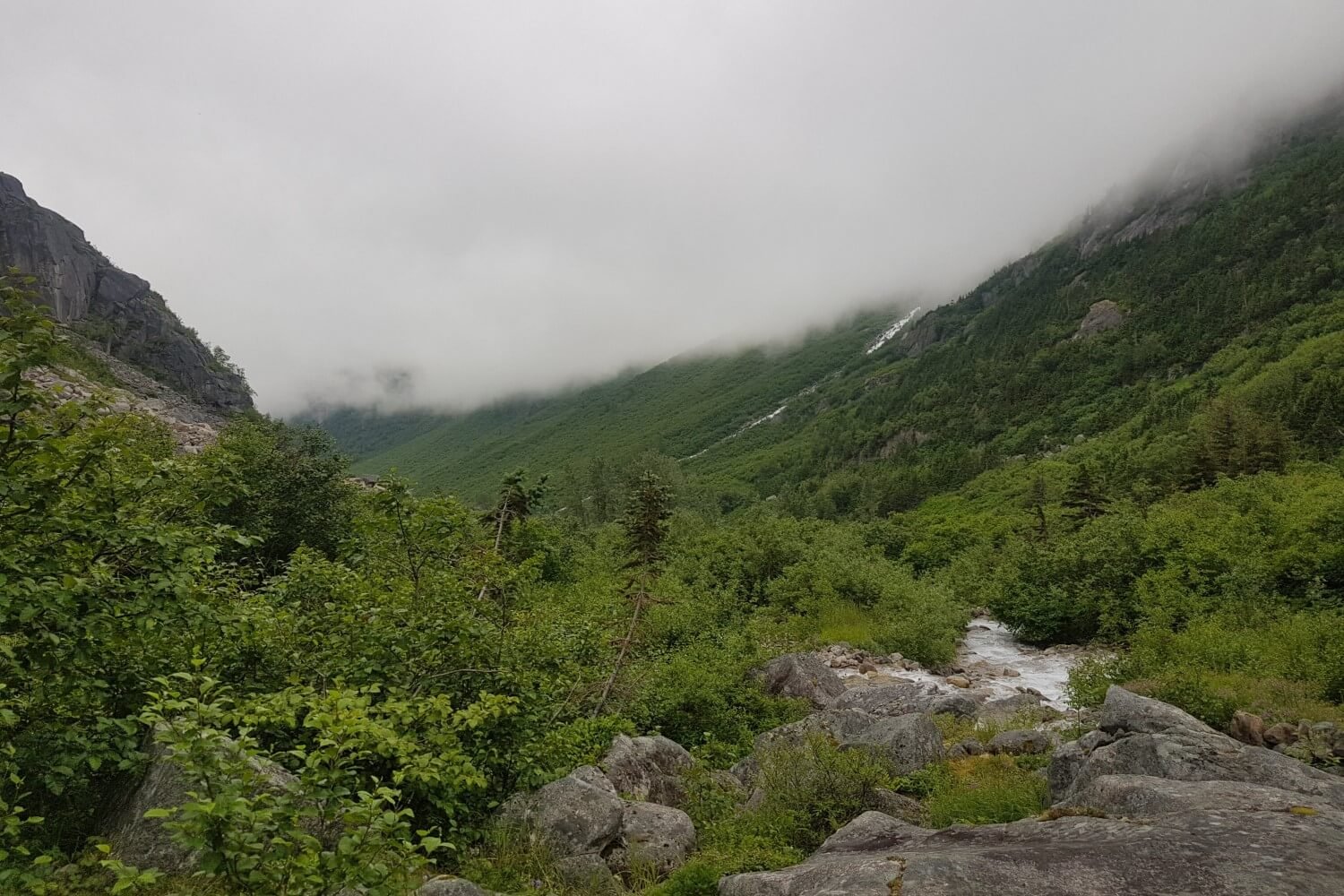
Looking back at the fog-draped rainforest while climbing to the Pass
At the top of the Pass there is a small cabin that makes for a welcome lunch spot if the weather is not cooperating. Heading down the Canadian side, you travel through a surreal subarctic landscape, full of bright blue glacial lakes, colourful lichens, wildflowers, and mountain vistas—a dramatic change from the first days spent in dense green rainforest.
Happy Camp is 4 miles (6.4 km) from the summit of Chilkoot Pass. There is a small cook shelter that offers the only protection from the elements here above the treeline. Near the mouth of Long Lake, with unobstructed views of surrounding peaks, this campground is one of the highlights of the trail. Being the first campground following Sheep Camp, it is also one of the busiest. It pays to start this day early.
From Happy Camp, the trail continues gently downhill along the shore of Long Lake. Reach the Deep Lake Campground after 2.5 mi (4 km). The hiking follows lakeshores for most of the day. You will follow Deep Lake and Lindeman Lake before arriving at Bare Loon campground, with campsites right on Bare Loon Lake.
Day five is mostly easy hiking downhill to Bennett Lake. Bennett was a bustling tent city during the gold rush, reaching a population of 20,000 during its zenith. All that remains now is an abandoned church and the Bennett Lake train station, where you can catch the White Pass and Yukon Route train back to Skagway.

Setting up at Happy Camp
WHEN TO GO
Snow persists at higher altitudes on the Chilkoot Pass well into July. The most favorable conditions are from late July to early September, but it is possible to attempt the trail from early June onward.
CAMPSITES
There are nine designated campgrounds, including one at the trail’s end on the shore of Bennett Lake. The trail is designated a National Historic Site on both the American and Canadian sides, so all campgrounds are well maintained. Sites on the American side (Finnegan’s Point to Sheep Camp) are all in deep temperate rainforest along the Taiya River.
Crossing over the Chilkoot Pass into Canada, the first campground is Happy Camp. Surrounded by eye-popping subarctic landscapes and above the treeline, this is the most exposed campground on the trail. Beyond Happy Camp, the campgrounds are situated on the shores of sprawling, ice cold lakes.
From south to north, the campgrounds—and distances between them—are:
Dyea Trailhead to Finnegan’s Point: 5 mi (8 km)
Finnegan’s Point to Canyon City: 2.7 mi (4.5 km)
Canyon City to Pleasant Camp: 3 mi (5 km)
Pleasant Camp to Sheep Camp: 2.3 mi (3.4 km)
Sheep Camp to Happy Camp: 7.5 mi (12.1 km)
Happy Camp to Deep Lake: 2.5 mi (4 km)
Deep Lake to Lindeman City: 3 mi (4.8 km)
Lindeman City to Bare Loon Lake: 3 mi (4.8 km)
Bare Loon Lake to Bennett Lake: 4 mi (6.4 km)
During the designated summer hiking season (June 1-Sept 13), everyone camping or day hiking along a section of the Chilkoot Trail must first secure a permit. Permits become available in two-week increments, about a month before the departure date. You must call a reservation line to secure permits for both the American and Canadian side of the trail.
NAVIGATION
MAPS: National Geographic produces a waterproof 1:63,360 scale topographic map of the Chilkoot Trail. It details amenities on the trail and features insets contextualizing the historical artifacts you will see along the way.
The map is usually available for purchase online at Alaska Geographic and at the Klondike Gold Rush Museum Book Store in Skagway.
WATER
WATER ACCESS: Water is plentiful throughout the trail. The only section without abundant access is between Sheep Camp and Chilkoot Pass. Even then, carrying 2 L is usually more than enough to get you between access points.
WATER TREATMENT: The glacial water along the Chilkoot runs clear, but risks from pathogens and bacteria remain. Be prepared to filter or purify all your drinking water along the trail.
Rarely are you far from a raging river or backcountry lake on the Chilkoot
WILDLIFE
BEAR SAFETY: Bear sightings on the Chilkoot Trail are almost a given. Due to the high volume of both bears and human visitors, park staff go above and beyond to communicate bear safety. You will hear from a ranger when picking up permits and again at Sheep Camp during the nightly ranger presentation.
To reduce the likelihood of a bear encounter gone wrong, make noise while hiking and be sure to carry bear spray. All campgrounds have bear lockers to store all food and scented items. Keep your meal preparation confined to the cooking shelters or picnic tables at each campground.
OTHER WILDLIFE: Southeast Alaska and northern BC is prime habitat for moose, elk, wolf, marmot, and a host of other subalpine mammal species. Be respectful of any wildlife you encounter by keeping a safe distance and always practicing Leave No Trace ethics.
TRAILHEAD SERVICES
Dyea Trailhead
There are no services at the Dyea trailhead other than a front country campground, where many hikers stay to get an early start on the trail. There is a parking lot at the campground where hikers can reliably park their vehicles during the hike.
Bennett Lake Trailhead
There is no road access to the trail’s northern terminus at Bennett Lake. To complete the Canadian side of the trail or to get back to Skagway after completing the entire route, you need to book a ticket for the White Pass and Yukon Route train, which stops a few times a day at the Bennett Lake station.
The only other ways to and from this trailhead is by chartered float plane or helicopter.
Skagway
Skagway is 10 mi (16 km) from the Dyea trailhead. The Chilkoot Trail Center—where you will pick up your permits—is in town. There is also a grocery store, several outdoor stores, and a few hotels.
The White Pass and Yukon Route train station is also in Skagway. If you’re ending your hike with the train ride from Bennett Lake, you will need to find a way back to your car in Dyea. The Dyea-Chilkoot Trail Transport shuttle is the most reliable option. Make a reservation before your trip!
Whitehorse
Located about 100 mi (160 km) north of Skagway, Whitehorse is the biggest city in all of Canada’s northern territories. Many hikers begin and end their Chilkoot adventure here. It has an airport with direct flights to major Canadian cities, many accommodation options, and an abundance of outdoor retailers where you can make any last-minute gear purchases.
Skagway train station
WHAT TO PACK
The Chilkoot Trail is in bear country. The surrounding area is home to a large population of both grizzlies and black bears. It is strongly recommended that every member in your party carries bear spray and knows how to use it appropriately.
If you are completing the full trail and crossing the Canada-US border, your bear spray canister must be clearly labelled for use on animals only and its weight/volume must not exceed 500 g / 500 ml.
Bear spray is prohibited on commercial flights. If you are flying into Whitehorse before your hike, set a reminder to purchase or rent bear spray before setting off for the trail. Yukon Wide Adventures in Whitehorse offers bear spray rentals. You can also purchase canisters in Skagway at Duff’s Backcountry Outfitters.
Lastly, be sure you have a physical copy of your train ticket from Bennett Lake back to Skagway. Being stuck without a ride home is probably not the note you’d like to end your Chilkoot journey on!
MORE INFORMATION
If you loved this destination guide, then you'll likely love reading about our other inspiring hiking destinations:
Or perhaps traversing some of our other hiking and backpacking content:
Or check out our entire list of Gear Reviews, Knowledge Base Articles, or Destination Guides for more hiking, backpacking, and outdoors related content.