

Sunshine Coast Trail Hiking Guide for 2023
JUMP TO: PROS & CONS | ITINERARIES | TRAIL DESCRIPTION | WHEN TO GO | HOW TO GET THERE | HUTS & CAMPSITES | NAVIGATION | WATER | WILDLIFE | TRAILHEAD SERVICES | WHAT TO PACK
Author: Steve Edgerton | Updated: Feb 15, 2023
We may earn a commission when you buy through our links. Learn more.
The Sunshine Coast Trail is a 110 mile (178 km) point-to-point hike in British Columbia, Canada. Traversing through the old growth forests and over the peaks of the north Sunshine Coast, it is the longest hut-to-hut hike in the country.
The trail can be completed exclusively by staying in the 14 backcountry huts along the trail, but there are also more than a dozen primitive backcountry campgrounds. You will camp underneath ancient Douglas firs, on the shores of ink black backcountry lakes, and watch the sunrise from mountaintop huts.
Unlike nearly every other long-distance hike in North America, the Sunshine Coast Trail is completely free. There are no permits and no reservations required, even for the huts. It is one of the West Coast’s best kept secrets, but don’t expect it to stay that way for long.
PROS
Stay in backcountry huts for your entire 10-14+ day hike
Beautiful old growth forest, backcountry lakes, and alpine views
No permits or reservations makes trip planning easier
CONS
Long portions of the trail have limited water access
Huts can fill up fast during peak hiking season
Sections of trail pass through old cut blocks and on forestry roads
ITINERARIES
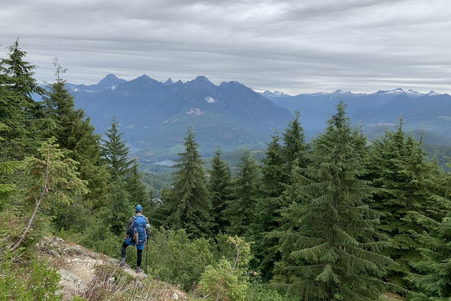
The Sunshine Coast Trail begins at Sarah Point, the northernmost tip of the north Sunshine Coast, and travels down to its southern terminus at Saltery Bay. The trail isn’t in a single park system: it traverses a patchwork of regional parks, conservation areas, and managed forestry land. The presence of the forestry industry and regular road crossing make it a little different than the pristine backcountry trails in Canada’s national parks. However, the result is still an authentic and beautiful experience through one of the most amazing ecosystems on the planet.
The road to the Sarah Point trailhead is incredibly rugged and beyond the capabilities even of some AWD vehicles. For this reason, almost all hikers begin the hike at Sarah Point and leave their cars at Saltery Bay, relying on the Sunshine Coast Trail Shuttle to provide safe transport to Sarah Point.
Sarah Point: Mile 0 of the Sunshine Coast Trail
Beyond starting at the north end, options for itineraries are near endless. It can be fastpacked in four to seven days or hiked over two weeks. You can stay exclusively in huts, primitive campgrounds, or a mix of both to suit your daily mileage. You can spend a night at a hotel as you pass through Powell River. You can even begin by taking on a single section of trail if the whole thing is too much of a commitment.
Because you do not need to reserve specific sites in advance, it is also easy to change plans on the fly, going longer if you feel good and the weather is nice, while cutting other days short if you are experiencing the opposite.
The flexibility and abundant camping options mean exact trip schedules are rarely repeated. So, rather than prescribing a specific itinerary, this guide takes a more general approach, describing the huts, campgrounds, and the trail between them to help you build your perfect trip on the Sunshine Coast Trail.
Hut-to-hut hiking at its finest
THE SUNSHINE COAST TRAIL
LENGTH: 110 mi / 178 km
DURATION: 7-14 days
TYPE: Point-to-Point
START: Sarah Point Trailhead
FINISH: Saltery Bay Trailhead
BEST TIME: May to September
The Sunshine Coast trail begins at Sarah Point, where the forest meets the Salish Sea. There is a campground with tents pads and amazing ocean views right at the trailhead. It is a great option if you are arriving late and are looking for an early start to your hike.
From the campground, the trail begins through airy forest dominated by sea-air loving arbutus trees. Climbing further into the Coast Mountains, the forests become dense, laden with ferns, and home to some of the oldest, largest Douglas fir and red cedar trees on the planet.
The trail continues through mostly viewless but enchanting old growth for 9 mi (15 km), until it arrives at Wednesday Lake. There is a campground with tent pads along the lakeshore. Before continuing, fill up your water here: there is no water access on the trail as it ascends up and over Manzanita Bluff.
If you stay at the Manzanita Bluff Hut, as many do for the first night, you will need enough for the strenuous hike up, cooking water for dinner and breakfast, plus some more to begin the next morning. We had three litres each and wished for a little more.
The uphill hike from Wednesday Lake to Manzanita Bluff, packs heavy with water, is a grind. Fortunately, big rewards await at the summit. You arrive to commanding views of the Salish Sea and the Manzanita hut is one of the nicest on the entire trail.

The cozy and scenic hut atop Manzanita Bluff
Beyond Manzanita Bluff, the trail plunges back into a valley, and then up and over an unnamed peak. It continues through rolling terrain on twisted, rooty singletrack for another 6 mi (10 km) until arriving at the Plummer Creek campground. For us, during the hot and dry July of 2021, this was the first reliable water source since Wednesday Lake, 7 strenuous miles behind us.
The next 2.5 mi (4 km) to Homestead Creek campground is flat and quick. The trail then ascends toward Rieveley Pond, home of the second hut along the trail. Beyond Rieveley Pond, continue through sections of virgin forest and cut blocks. There are options for camping every 3-6 mi (5-10 km) during this section. The most scenic and well-used campgrounds are at Sliammon Lake and Little Sliammon Lake 25 mi (40 km) into the trail.

A night under old growth at Plummer Creek
Another burly climb up Scout Mountain begins after Sliammon Lakes, with expansive views of Powell Lake to the east and Scuttle Bay to the west. Coming off Scout Mountain, the trail bisects the town of Powell River. You will pass right by the Shinglemill Pub and Bistro. They conveniently offer free resupply services to thru hikers. A hot meal and cold beer after days on the trail was also impossible for us to walk by.
Leaving the Shinglemill, you will cross the bridge over the Powell River. Treat yourself to a hotel stay in town or continue to hike, following the contours of Powell Lake to Haywire Bay Campground. There is road access to Haywire Bay, so it is always busy in summer. Views of Powell Lake from the bay and hot showers make it a popular stop for thru hikers too.
On the most remote section of the trail past Confederation Lake
The trail leaves the campground and winds through lush temperate rainforest to Inland Lake. We saw more frogs, toads, and bird species than we could count while circumnavigating Inland Lake to the Primitive Anthony Island Hut.
Leave Inland Lake on a steep climb up to Confederation Lake, home to another one of the nicer huts. This section is among the most remote, difficult, and beautiful of the entire trail. The hiking is steep, but the scenery is transfixing. Huge backcountry lakes—Confederation, Giovanno and Haslem—teem with life, as do the surrounding forests. You get panoramic views of all of them at the summit of Tin Hat Mountain, the trail’s highpoint, both figuratively and literally.
Tin Hat Hut is right on the summit. Its setting and the surrounding views make it one of the most memorable moments of the trail. Whatever your itinerary, you must plan to spend a night atop Tin Hat Mountain.
An evening at the iconic Tin Hat Mountain Hut
A steep descent takes you down the south side of Tin Hat Mountain. Again, you will traverse sections of old growth and cut blocks, crossing active forestry roads. The difference between the two can be jarring. The Sunshine Coast Trail was created to protect the stands of unprotected old growth forest that remain in the region, an imperative you will share when hiking through old growth only to emerge into a cut block logged bare.
Lewis Lake lies near the 59 mi (95 km) mark of the trail and makes for another excellent camping option. Smaller lakes dot the trail past here. Elk Lake, at 68 mi (110 km), features the next hut.
Past Elk Lake, the trail diverges. Left is more scenic and flatter. Right is steeper but more direct. Both trails reconnect shortly before Coyote Lake at 73 mi (117 km), where you will find another campground. The next 2.5 mi (4 km) are relatively flat until you reach the base of Walt Hill. It is then a steep climb to the summit, where you will find another scenic hut with views of the valley and distant Coast Mountains further inland.
The next section of hiking is flat, again weaving in and out of cut blocks. At 84 mi (135 km) the trail crosses Dixon Road. A 2.5 mi (4 km) detour down the road will take you to Lang Bay, the last convenient resupply point on the trail.
Across Dixon Road, you will ford Lois River. Look for orange markers on the opposite shore to guide you. After the river, the trail mostly follows logging roads until Lois Point campground on the sprawling Lois Lake.
Morning coffee doesn’t get better than this
Leaving the shores of Lois Lake, begin a short climb up to Golden Stanley Hut. Past the hut, the trail continues to climb steadily through the forest towards the summit of Mount Troubridge. The final highpoint of the trail, the views from the summit are spectacular. There is an emergency shelter located on the peak, but don’t plan to spend the night here—it is cramped and exposed. Mount Troubridge Hut, just before the summit, is a better option.
Descend off Mount Troubridge for the final section of the trail. Steady hiking downhill will get you to Rainy Day Lake, home the second last hut. From Rainy Day Lake you can backtrack half a mile for an alternate route. This 5 mi (8 km) of trail mostly parallels Saltery Bay and passes Fairview hut along the way. Continuing straight past the Rainy Day Lake Hut offers a slightly shorter and steeper detour through the forest.
Both trails meet again just before the southern trailhead at Saltery Bay. A short walk down the highway to the parking lot is all that remains to complete the epic Sunshine Coast Trail!
Last night on the SCT
WHEN TO GO
The best time to do the Sunshine Coast Trail is during the dry season from May to September. Fall and winter are wet, but the moderating influence of the sea means that the Sunshine Coast is never as cold or snowy as other Canadian mountain regions. Some of the huts are fully winterized too, so completing the hike in the offseason is possible if you are okay with slogging through endless rain and mud!
HOW TO GET THERE
Although the Sunshine Coast is not an island, it feels like one. Encircled by mountains, there is no road access from mainland British Columbia to the region. To get there, you will need to catch a ferry from Horseshoe Bay, just north of Vancouver, to Langdale on the south Sunshine Coast. From there, it is a 90 minute drive to Earl’s Cove, where you must catch another ferry to Saltery Bay on the north Sunshine Coast, the endpoint of the trail.
The Earl’s Cove to Saltery Bay ferry does not take reservations. Get to the ferry terminal early, especially if you have a shuttle booked the same day to take you from Saltery Bay to the northern trailhead at Sarah Point. Sarah Point is a 90 minute drive from Saltery Bay.
HUTS & CAMPSITES
With 14 huts, even more primitive sites, and a few drive-in frontcountry campgrounds, camping options are abundant along the trail. You can count on passing two or three primitive campgrounds between each hut. They are all identified on official maps. Most of the huts also have clearings surrounding them suitable for a tent.
Be mindful that the primitive campgrounds are quite spare. Most have one or two tables and usually an outhouse. Some have wooden tent pads; some are just semi-official clearings in the forest. Be ready for a real backcountry feel!
From north to south, the huts — and distances between them — are:
Sarah Point Trailhead/Campground to Manzanita Bluff Hut: 10 mi (16 km)
Manzanita Bluff Hut to Rieveley Pond Hut: 10.8 mi (17.4 km)
Rieveley Pond Hut to Powell River: 10.7 mi (17.2 km)
Powell River to Anthony Island Hut: 10.1 mi (16.2 km)
Anthony Island Hut to Confederation Lake Hut: 4.5 mi (7.3 km)
Confederation Lake Hut to Tin Hat Hut: 9.4 mi (15.2 km)
Tin Hat Hut to Elk Lake Hut: 12.4 mi (20 km)
Elk Lake Hut to Walt Hill Hut: 8.8 mi (14.1 km)
Walt Hill Hut to Golden Stanley Hut: 14 mi (22.6 km)
Golden Stanley Hut to Troubridge Hut: 7.1 mi (11.5 km)
Troubridge Hut to Troubridge Emergency Shelter: 1.1 mi (1.8 km)
Troubridge Lake Hut to Rainy Day Lake Hut: 5.9 mi (9.5 km)
Rainy Day Lake Hut to Fairview Hut: 2 mi (3.2 km)
Fairview Hut to Saltery Bay Trailhead: 4.2 mi (6.8 km)
The huts and primitive campgrounds do not require reservations or permits. Haywire Bay is a first come first-serve car-accessible campground about 5 mi (8 km) past Powell River. Sites are $25 CAD per night.
Partaking in some frontcountry luxuries at Haywire Bay
NAVIGATION
MAPS: Tourism Powell River publishes a 1:75,000 scale topographic map of the trail. You can purchase it at the Powell River Visitor Information Centre in town, or from the Sunshine Coast Shuttle when making your reservation. There is also an official guidebook available for purchase online or at the Visitor Information Centre.
The Sunshine Coast Trail Association has created high quality, georeferenced maps of every section of the trail. You can download these—for free—as PDFs or with the GPS app Avenza for additional navigational aid.
WATER
WATER ACCESS: Depending on the time of year, water access can be challenging, especially the stretch from Sarah Point to Powell River. In July, many creeks were completely dry or held only puddles of sitting water.
Even during the rainy season, the climbs up Manzanita Bluff, Tin Hat Mountain, and Mount Troubridge all require extra capacity: 3-4 litres per person at minimum. There are usually signs indicating last opportunities for water before prolonged dry stretches.
WATER TREATMENT: Water from creeks and lakes was often turbid, so you will appreciate a filter that is easy to clean or a little more robust to deal with sediment. We used the Katadyn BeFree 3L water filter. The filter cap is easy to clean, and the large bladder provided necessary extra capacity on the dry sections.
Lush rainforest doesn’t always guarantee easy water access
WILDLIFE
BEAR SAFETY: Like anywhere in the western Canadian backcountry, bears are the biggest wildlife concern on the Sunshine Coast Trail. There are not many grizzlies in the region, but black bears are abundant.
Bears like to frequent the sunny cut blocks, where the dense underbrush is full of wild blackberries and raspberries. Make noise when hiking through dense vegetation and when approaching moving water. Be prepared with bear spray as well.
OTHER WILDLIFE: The Sunshine Coast is a temperate rainforest and is home to a rich diversity of plant and animal life. We saw moose, deer, eagle, osprey, grouse, tree frogs, toads, and more during our trip.
TRAILHEAD SERVICES
Sarah Point Trailhead
There is a campground and a new hut under construction right at the Sarah Point Trailhead. Other than that, there are no services. It is only accessible via an old utility road. The final few miles are rugged and steep. Use extreme caution if taking your own vehicle. An AWD vehicle is mandatory if you wish to make it out again.
Saltery Bay Trailhead
The Saltery Bay Trailhead is where most choose to conclude their hike. The nearby paid parking lot is the best place to leave your car for your trip. The Saltery Bay ferry terminal is also walking distance from the trailhead. The closest services beyond this are in Powell River, 20 mi (32 km) to the north.
Powell River
The only town on the north Sunshine Coast, Powell River is a hub for the local forestry industry. Right on the Salish Sea and surrounded by endless miles of forest and lakes, it is rapidly becoming an outdoor tourism and recreation hotspot as well. There are several great hotels and restaurants. Powell River Outdoors is your best option for any last-minute gear needs.
Stunning Salish Sea views
WHAT TO PACK
Although you can easily hike the Sunshine Coast Trail staying exclusively in the huts, it is still worthwhile to bring your own shelter. No permit system means the popular huts can fill up quickly, especially on summer weekends. Bring a lightweight tent, a tarp, or a bivy as a backup to avoid any uncomfortably cramped huts or exposed nights under the stars.
Many hikers will stay at some huts and some backcountry campgrounds. The huts have bear storage lockers but the primitive sites do not, so you will need to be prepared to safely store your own food with a bear proof canister, bag, or hang.
We relied on a simple bear hang with dry sack and paracord but would not recommend it. The giant cedars and firs made finding adequate branches for our hang extremely difficult. We would recommend an Ursack Major Bear Sack or a more traditional bear canister.
Canisters are heavier and bulkier, but far more dependable. Bear sacks will prevent bears (and other pests) from getting your food, but they can still smash it into inedible mush. Proper placement on trees and in rock features can mitigate this risk, but it will always remain a risk, though the savings in weight and in bulk may justify this for you.
Saltery Bay Trailhead
MORE INFORMATION
If you loved this destination guide, then you'll likely love reading about our other inspiring hiking destinations:
Or perhaps traversing some of our other hiking and backpacking content:
Or check out our entire list of Gear Reviews, Knowledge Base Articles, or Destination Guides for more hiking, backpacking, and outdoors related content.